Unconfigured Ad Widget

Collapse

Announcement

Collapse
No announcement yet.

CANNING TOWN/PLAISTOW - is there an expert out there?

Collapse
X
 
  • Filter
  • Time
  • Show
Clear All
new posts

  • CANNING TOWN/PLAISTOW - is there an expert out there?

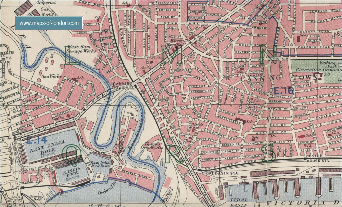
    Wonder if there is anyone who might be able to give me an idea how close together these two streets were

    CHARLOTTE STREET - Plaistow - address from 1881 census

    CATHERINE STREET - Plaistow - address where died January 1882

    Also any hints as to approximately where they would have been on a modern map

    Thanks in advance for any help

    Sue
    Hunter Valley NSW Australia

  • #2
    They are very close. Go to this page.

    Look for square with the large letter: R
    Slightly to the right of it is Charlotte Street and above it is Catherine Street

    This area was destroyed in WWII. This is a modern map and you'll see the street names have been lost.
    appleby road - Google Maps

    Hope this helps.
    Phil
    historyhouse.co.uk
    Essex - family and local history.

    Comment


    • #3
      In 1881 Charlotte Street is in district 19b of West Ham, Essex, and Catherine Street is in the same enumeration district, so they must have been pretty close to each other. St Luke's Parish, Plaistow Ward. The boundaries of the enumeration district are given as North Woolwich Road, Hack Road, open fields to Alice Street, Alice Street to North Woolwich Road. The other streets included were Sarah Street, Sidney Street, and Junction Street.

      The only one of these that I can see on the modern-day map is North Woolwich Road, which is between Royal Victoria Dock and the river. There are loads of warehouses, works, etc marked around there so I suppose the streets must have been demolished and replaced by some industrial buildings.
      KiteRunner

      Every five years or so I look back on my life and I have a good... laugh"
      (Indigo Girls, "Watershed")

      Comment


      • #4
        Thanks so much for helping me try to work this out - like you KiteRunner the only road name I recognised on a modern map from the description of the enumeration district was North Woolwich Road - and I wondered if these 2 streets were between the dock and the river - and also presumed as they were so close to the docks they would likely not have survived WW2 bombing

        The map is fantastic Phil it is so good to be able to pinpoint the location and look at the satellite view of the area on Google Maps - can't wait till you get 'Street View' over there to get an even better idea of localities

        The closeness of the streets helps me to be a little more sure that the man who died in Catherine Street may well have been my husband's GG GF ARTHUR KEENE who was recorded with his family in Charlotte Street in the 1881 census.

        I'm having trouble with (variously) Helen/Hellen/Ellen his 'wife' in census records/his son's birth certificate but recorded on the death certificate as his mother.

        I think I will have to get some more certificates ordered to try to clarify it some more

        Many Thanks Again

        Sue
        Hunter Valley NSW Australia

        Comment


        • #5
          Hi Sue

          I would have said that Charlotte St & Catherine St were in Custom House or Canning Town more than Plaistow, as Plaistow is a bit further from the docks.


          I'm not too sure of the date of Keldon's map, but I have The Godfrey OS Map of Canning Town 1894.

          Would you like me to scan in and send you it? It clearly shows Catherine & Charlotte Street with Sarah Street between them.

          If you have a present day map to hand, look at the Vic Dock Rd, above it you will see Appleby Rd - that is where the old Charlotte Street was approx.

          I come from that area, Mum was born in Canning Town - she was actually baptised in St Lukes Church which is right near Catherine Street, she then moved to Plaistow.


          Sandra

          ps. I also have the Canning Town & Custom House OS Map of 1914, also clearly showing the two streets, and Canning Town 1867 which just shows marshland in that area.
          Last edited by Sandra; 12-12-08, 08:56. Reason: spelling

          Comment


          • #6
            can't wait till you get 'Street View' over there to get an even better idea of localities
            Appleby Road appears to be post-WWII council housing. I believe much of the area is the same.
            Appleby Road, E16:: OS grid TQ4081 :: Geograph British Isles - photograph every grid square!

            This site referred above is the nearest you will get at the moment to 'Street View', but it may help.
            Geograph British Isles - photograph every grid square!
            Phil
            historyhouse.co.uk
            Essex - family and local history.

            Comment


            • #7
              Phil - what an amazing site - thanks so much for passing it on - I can see much time being 'wasted' on it!!

              Sandra - thank you too very much for the extra info and the PM - I used Plaistow as that was where the 2 streets were listed as on the census and the death certificate - but I tend to agree that it is a fair way from present day Plaistow

              I'm certainly interested in the other maps too - from the website of the map Keldon gave it looks to be as late as 1940 so it would be interesting to see the development. St Luke's Church looks to have been pretty impressive and it's good to see that the building is still making a useful contribution to the local community.

              Thanks again for all the assistance here - will get back to you by PM Sandra

              Sue
              Hunter Valley NSW Australia

              Comment


              • #9
                Originally posted by SueNSW View Post
                The map is fantastic Phil it is so good to be able to pinpoint the location and look at the satellite view of the area on Google Maps - can't wait till you get 'Street View' over there to get an even better idea of localities Sue Hunter Valley NSW Australia
                There is street view for UK maps from google - click the little yellow figure at the bottom right of the map and drag it to where you want to look.

                Some rural areas have not been done and some roads excluded, not sure why but maybe private land.

                Margaret
                Last edited by margaretmarch; 21-08-16, 15:12.

                Comment


                • #10
                  Originally posted by margaretmarch View Post
                  There is street view for UK maps from google - click the little yellow figure at the bottom right of the map and drag it to where you want to look.

                  Some rural areas have not been done and some roads excluded, not sure why but maybe private land.

                  Margaret
                  The maps on the National Library of Scotland website are amazing
                  Home page http://maps.nls.uk/
                  The side by side one is just one with many variations available. Others are well worth exploring
                  John P

                  PS it was my first posting on the forum. I was surprised to see such a quick response bearing in mind the previous post was in 2008. Obviously I have a lot to learn - who's Phil ?

                  Comment


                  • #11
                    Hi John, and welcome to the forum. Keldon has the name Phil at the bottom of his posts.

                    Comment


                    • #12
                      Was surprised to see this old thread revived - certainly there have been a lot of new sites/features made available to us over the last 7/8 years - use Street View all the time now in the UK and agree the NLS maps are a great addition

                      Probably wouldn't need to ask the question now with so much currently accessible online

                      Cheers Sue

                      Comment


                      • #13
                        Hi Sandra. I wondered if you knew any of the history behind Catherine Street and why it is not there any longer? I am researching my Great Grandmother's family who lived at 21 Catherine Street in 1929. I understand the area was heavily destroyed during the Blitz, with one of my Great Aunts being killed in the September the Blitz started on Mortlake Road (Ilford). We are visiting London in October from New Zealand, and I have been hoping to retrace some family addresses - but I see Catherine Street is no longer there. Is the Church still there? We would like to visit the area, but it is a long way to go if it is of little sentimental value! Thank you, Sarah.

                        Comment

                        Working...
                        X